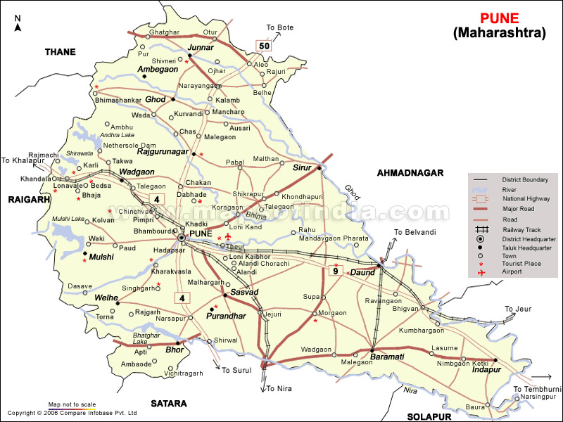
My Village

My Photo
Name:
Location: London, United Kingdom

A confident motivated marketing professional and a strong educational background together with good interpersonal skills, an ability to interact with people at all levels with managerial and teamwork experience.

Tuesday, August 15, 2006

My District - Pune


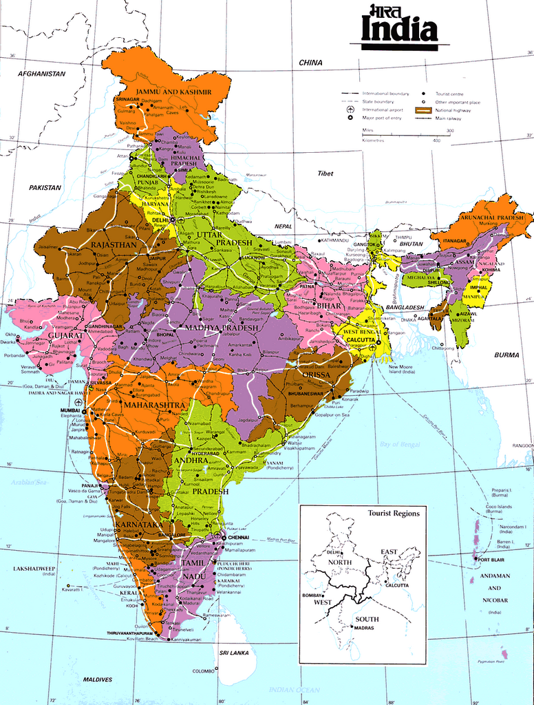
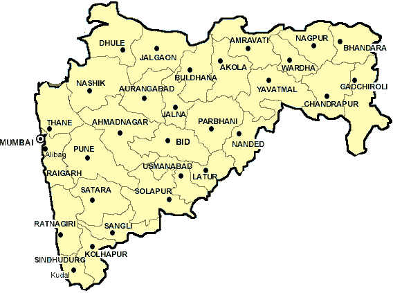
Pune (IPA: pʊɳe, Marathi: पुणे) is a city located in the western Indian state of Maharashtra, and also the capital of Pune District in which it is located. It is the 8th largest city in India with a population of 4.5 million, and the second largest in the state of Maharashtra. It is located roughly 160 kilometres east of Mumbai at an altitude of 560 metres above sea level. It is situated at the eastern edge of the Western ghats on the Deccan plateau.

Pune has a reputation for its several esteemed colleges and educational institutions, and is also home to many software and IT companies. Pune is widely considered the cultural capital of Marathi-speaking Maharashtrians. Although Marathi is the main language of Pune, its cosmopolitian population speaks several other languages like English, Hindi and Gujarati.

Pune started out as Punnaka - an agricultural settlement in the 8th century. The earliest evidence (copper plates dating 758 AD and 768 AD) reveals that this region was ruled by the Rashtrakutas. It came under mughal rule in the 11th century.

Until circa 1818, it continued to be ruled by various dynasties, especially the Mughals and the Marathas. During the mid 17th century, it became the temporary residence of Marathi King Shivaji. In 1749 A.D, it prominence as the capital of the Maratha kingdom under the Peshwa rule. It was during this period that the city expanded considerably[1].

Pune's medieval roots are also evident in number of temples and mosques. The oldest existing structure in the city is the rock-cut temple of Pataleshwar, from the 8th century AD. The cave-temple complex is also called Panchaleshvara cave. This cave, once situated outside limits of the old town, is now squarely in the middle of the city off the Jungli Maharaj road.

Pune is inextricably linked to the life of the great Maratha hero and king, Chhatrapati Shivaji. The era of Pune's fame began when Chhatrapati Shivaji came to stay here with his mother Jijabai in 1635-36. They lived in a mansion known as "Lal Mahal," a replica of which still can be visited at its original location in the city. According to local lore, the Kasba Ganapati Mandir, regarded as the presiding deity of the city (gramadevata), was built by Jijabai.

Pune is located at 18°32' North 72° 51' East (See satellite view), near the western margin of the Deccan Plateau. It lies on the leeward side of the Sahyadri ranges and Western Ghats, 560 m (1837 ft) above the sea level, at the confluence of Mula and Mutha rivers, which are tributaries of the Bhima. Two more rivers, Pavana and Indrayani traverse the Northwestern outskirts of the urban area. The Sinhagad-Katraj-Dive Ghats range is the Southern Boundary of the urban area. The highest point in the city is Vetal Hill (800 m or 2625 ft above sea level) whereas the highest point just outside the urban area is the Sinhagad Fort (1300 m or 4265 ft above sea level).

English dailies such as the Indian Express and The Times of India have editions based out of Pune, with additional local supplements. Marathi newspapers such as Sakal, Loksatta, Kesari and Pudhari are equally, if not more, popular with Punekars.

All professional colleges in Pune are affiliated to the University of Pune, one of the largest universities in the world in terms of matriculation. Prominent ones include:Deccan College (one of the oldest in western India) College of Engineering, Pune (second oldest in the Subcontinent)
Fergusson College, established 1885 (amongst ten most reputed in India) Agricultural College (one of the earliest in the country) Gokhale Institute of Politics and Economics (one of the oldest, and also one of the most reputed institute for research and higher studies in Economics in India)
Symbiosis Institutes.


Official websites

Pune City Guide
Pune Municipal Corporation E-Governance
Pune news
Interactive Map of Pune
Pune Classifieds
Pune Forums
A list of Bloggers from Pune

My State - Maharashtra


Maharashtra (Marathi: महाराष्ट्र mahārāṣṭra, literally: Great Nation; IPA: /məhaːraːʂʈrə/)(pronunciation (help·info)) is India's third largest state in terms of area and second largest in terms of population after Uttar Pradesh. It is bordered by the states of Gujarat, Madhya Pradesh, Chhattisgarh, Andhra Pradesh, Karnataka, Goa and the Union territory of Dadra and Nagar Haveli. The Arabian Sea makes up the state's western coast. Mumbai (Bombay), India's largest city, is the capital of Maharashtra.

Maharashtra was known as Rashtra in the Rig Veda, Rashtrik in Ashoka's inscriptions, and Maha rashtra afterwards, as attested by Huein-Tsang and other travellers. The name appears to have been derived from Maharashtri, in an old form of Prakrit, an ancient Indian language

Not much is known about Maharashtra's early history, and its recorded history dates back to the 3rd century BC, with the use the Maharastri language, a Prakrit corruption of Sanskrit. Maharashtra was known as Dandakaranya, i.e. the jungle (aranya) which bound by rules (dandakas). Later, Maharashtra became a part of the Magadha empire, ruled by the Buddhist emperor Ashoka. The port town of Sopara, just north of present day Mumbai, was the centre of ancient India's commerce, with links to Eastern Africa, Mesopotamia, Aden and Cochin. With the disintegration of the Mauryan Empire, Maharashtra came under the rule of the Satavahanas between 230 BC and AD 225.

During the reign of the Vakatakas (AD 250525), Vidarbha, the eastern region of Maharashtra, come under their rule. During this period, development of arts, religion and technology flourished. By the 6th century, Maharashtra came under the reign of the Chalukyas from Badami. Later, in 753, the region was governed by Rashtrakutas, an empire that spread over most of peninsula India. In 973, the Chalukayas of Badami expelled the Rashtrakutas, and ruled parts of Maharashtra until 1189 when the region came under the hands of the Yadavas of Deogiri.

Maharashtra came under Islamic influence for the first time after the Delhi Sultanate rulers Ala-ud-din Khalji, and later Muhammad bin Tughluq appropriated parts of the Deccan in the 13th century. After the collapse of the Tughlaqs in 1347, the Bahmani Sultanate of Bijapur took over, governing the region for the next 150 years. By the 16th century, central Maharashtra was ruled by numerous autonomous Islamic kingdoms that owed allegiance to the Mughals, while coastal region was annexed by the Portuguese, in their quest to seize control of the spice trade.

By the early 17th century the Maratha Empire began to take root. The Marathas, native to western Maharashtra, were led by Chhatrapati Raje Shivaji Bhosale, who was crowned king in 1674.

Shivaji's son and successor, Sambhaji Bhosale was captured and executed by Aurangzeb, the Mughal in the late 1680s. The Mughals forced Sambhaji's younger brother, Rajaram Bhosale to flee into the Tamil-speaking countryside. He repaired to the great fortress of Jinji (sometimes anglicised to Ginjee) to barely recover in the early 18th century, in somewhat changed circumstances.

Maharashtra encompasses an area of 308,000 km² (119,000 mi²),and is the third largest state in India after Rajasthan and Madhya Pradesh. Maharashtra is bordered by the states of Madhya Pradesh to the north, Chhattisgarh to the east, Andhra Pradesh to the southeast, Karnataka to the south, and Goa to the southwest. The state of Gujarat lies to the northwest, with the Union territory of Dadra and Nagar Haveli sandwiched in between. The Arabian Sea makes up Maharashtra's west coast.

The Western Ghats are a hilly range running parallel to the coast, at an average elevation of 1,200 metres (4,000 feet)). To the west of these hills lie the Konkan coastal plains, which is 50 – 80 kilometres in width. To the east of the Ghats lies the flat Deccan Plateau. The Western Ghats form one of the three watersheds of India, from which many South Indian rivers originate. To the north of the state, near the Madhya Pradesh border, lies the Satpura Range. The various sections of the Western Ghats of Maharashtra are Tamhini Ghat, Varandha Ghat and Sawantwadi Ghat.

Other Links:

Govt. of India directory – A directory of websites of the Government of Maharashtra
Official site of the Maharashtra govt
Maharashtra tourism official site
Indtravel – An overview of the state.
District-wise Statistics
India Picture – Photos from several places in Maharashtra.
Maayboli – A bilingual directory of Marathi and Maharashtra related resources.
Mumbai Yellowpages
Maharashtra city guides
Listen Maharashtra Music

India - My Mother land

India, officially the The Republic of India, (Hindi: भारत ) is a country in South Asia. It is the seventh-largest country by geographical area, the second most populous country, and the largest liberal democracy in the world. India has a coastline of over seven thousand kilometres,[1] and borders Pakistan[2] to the west, Nepal, the People's Republic of China and Bhutan to the north-east, and Bangladesh and Myanmar to the east. In the Indian Ocean, it is adjacent to the island nations of Sri Lanka, Maldives and Indonesia.

India is referred to as the largest democracy in the world, by virtue of the fact that it has the largest electing population among democratic countries. The country has a federal form of government and a bicameral parliament operating under a Westminster-style parliamentary system. It has three branches of governance: the Legislature, Executive and Judiciary.


The territory of India constitutes a major portion of the Indian subcontinent, situated on the Indian Plate, the northerly portion of the Indo-Australian Plate, in southern Asia. India's northern and northeastern states are partially situated in the Himalayan Mountain Range. The rest of northern, central and eastern India consists of the fertile Indo-Gangetic plain. In the west, bordering southeast Pakistan, lies the Thar Desert. The southern Indian Peninsula is almost entirely composed of the Deccan plateau, which is flanked by two hilly coastal ranges, the Western Ghats and Eastern Ghats.

India is home to several major rivers, including the Ganga, Brahmaputra, Yamuna, Godavari, Kaveri, Narmada, and Krishna. India has three archipelagos – Lakshadweep off the southwest coast, the Andaman and Nicobar Islands-volcanic island chain to the southeast, and the Sunderbans in the Gangetic delta in West Bengal.

India has a rich and unique cultural heritage, and has managed to preserve its established traditions throughout history whilst absorbing customs, traditions and ideas from both invaders and immigrants. Many cultural practices, languages, customs and monuments are examples of this co-mingling over centuries. Famous monuments, such as the Taj Mahal and other examples of Islamic-inspired architecture have been inherited from the Mughal dynasty. These are the result of a syncretic tradition that combined elements from all parts of the country.

Indian music is represented in a wide variety of forms. The two main forms of classical music are Carnatic from South India, and Hindustani from North India, each of which has several popular sub classes. Popular forms of music also prevail, the most notable being Filmi music. In addition to this are the diverse traditions of folk music from different parts of the country. Many classical dance forms exist, including the Bharatanatyam, Kathakali, Kathak, Kuchipudi, and Manipuri. They often have a narrative form and are usually infused with devotional and spiritual elements.

You can get more information on :

1. https://www.cia.gov/cia/publications/factbook/geos/in.html
2. http://en.wikipedia.org/wiki/India